
Geology / U.K.
The Silurian in Shropshire
Shropshire ➚, a small county of England bordering Wales is one of the most geologically diverse areas for its size in the world. There is a fairly continuous record of rocks ranging from 650 to 170 Million years ago. It was located in a coastal area up to the end of Silurian and many of the deposits were marine, thereafter swamp and desert rocks were deposited. Over this long period of time Shropshire has experienced ice ages, tropical, desert and equatorial conditions. During the Silurian, Southern England was in the process of migrating steadily North, (it was near the South Pole 500 million years ago) to its present northern latitude of 53° North.
The great diversity in this small area has interested geologists from the earliest days of the Victorian pioneers.
The most famous Silurian site in the world is Wenlock Edge. Here an ancient coral reef is now exposed as a long ridge of woodland set amongst the Shropshire hills. Because the Silurian saw a general rise in sea level after the Ordovician glaciation many land areas were inundated by shallow seas. Coral reefs flourished in areas of shallow water that were free of heavy deposition of mud.
The scenery has a classic escarpment and dale style resulting from the exposure of the gently sloping beds. The limestone is harder and forms ridges while the softer shales form the intervening dales. These are excellent conditions for mapping the area as you can just follow the exposures of beds of streams as they have cut through the escarpment into the shales. The rather surprising absence of vulcanicity so close to a plate margin is still a bit of a mystery, although it is true that the area consists of a relative stable geotectonic block bounded by major fault systems.
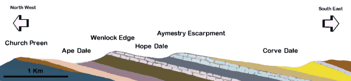
This section is based on a figure in Peter Toghill's excellent books 'Geology in Shropshire' and also 'The Geology of Britain: An Introduction' ➚
Key to the vertical section
| Ordovician | Wenlock Shale | Upper Ludlow Shales | |||
| Kenley Grit | Wenlock Limestone | Downton | |||
| Pentamerous Beds | Lower Ludlow Shales | Psammosteus Limestone | |||
| Purple Shale | Aymestry Limestone | Devonian |
This a classic section of the Lower Palaeozoic rocks. The basal Ordovician rocks are overlain at a slightly more steeply sloping layer by a clear uncomformity. The topmost Ordovician rocks belong to the Acton Scott Group or Onny Shales formations, these are of Caradoc Series Age. The gap in deposition at the base of the Silurian represents uplift and deformation during the last Ashgill Series of the Ordovician System (in this area a gap of about seven million years).
On top of this eroded surface, the Kenley Grit was deposited representing the fossilised shoreline at about 420 Million years ago, in some locations cliff lines and sea stacks can be seen. The whole Pridoli Series of the lowest Silurian is not present at this locality and earliest deposition is of Llandovery Series age.
The Pentamerus beds that followed are named after the Brachiopod : Pentamerus Oblongus that proliferated in the shallow seas. As the sea transgressed (the shoreline gradually moved inland) the species of Brachiopod change, as different species are indicative of particular sea water depths. The Purple Shale marks slightly deeper water deposits (indicated by the Brachiopod Clorinda).
This then moved into the Wenlock Series with the deposition of the Wenlock Shales. Then followed the Wenlock Limestone that forms Wenlock Edge itself. The underlying shale has increasing numbers of limestone nodules within it before the main limestone blocks, as thinly bedded platform limestone. Within the limestone are the coral or patch reef formations as lenticular structures. The reefs are the purest formation of calcium carbonate and were used in the blast furnaces of nearby Coalbrookdale. The clear, shallower waters that enabled these limestones to form then deepened when the Lower Ludlow Shales at the start of the Ludlow Series of the Silurian before limestone of the Aymestry formation was deposited. The Aymestry does not contain fossil reefs and has huge quantities of the brachiopod Kirkidum Knightii, after a further deposition of shale - the Upper Ludlow Beds the sea had retreated from the area. The transition to non-marine facies is marked by the Ludlow Bone Bed (made up of mainly fish spines and scales). The freshwater deposits now contain gastropods, bivalves and fish. In this area the beds above this level are called Old Red Sandstone - a hint of the arid desert conditions that were to come. The Downton series represents the youngest deposited Silurian rocks in the area and is capped by a thin non-marine limestone beds named after a common fossil 'Psammosteus' limestone. Fossil plants are quite commonly found in these beds. The Silurian-Devonian boundary in the UK represents the closure of the Iapetus Ocean and the termination of marine deposition. The final closure of the ocean was a complicated event and took many millions of years to complete.
Rocks of Devonian and Carboniferous age are found to the south-east of the area - most notably at the Clee Hills.