
Geology / Maps
The position of land masses as long ago as four hundred million years ago was totally different to that of today. With the motion and collision of the plates that make up the earth's crust the location and climate of familiar 'hot' or 'cold' places bears little relation to the present day.
In the North Atlantic area the Silurian marked the closure of the great 'Iapetus' Ocean that separated present-day North America from Northern Europe. At that time, even though the boundary of the Eastern edge of North America was more or less in the same position as today, Newfoundland and a portion of Eastmost America was on the South of the ocean together with England and Ireland. Northern Ireland and Scotland were on the Northern flank. The end of the Silurian saw the formation of massive mountain ranges along the edges of the two continental margins, and in England, a move to deposition of sediments derived from the new mountains. This created the Devonian system.
The deposition of Silurian rocks was widespread worldwide.
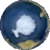
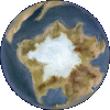
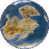
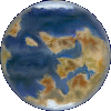
As at present, continental crust was not uniformly distributed. There was a vast area of ocean covering the North Pole and one 'side' of the Earth. The majority of land clustered around the South Pole to form the Gondwana super-continent.
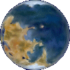
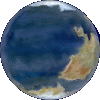
The following six maps indicate the location of the landmasses that were present in Silurian times. Most of the dry land formed one vast continent near the South Pole. These are artist's impressions - all cloud cover has been removed. Much of this area may have been covered by shallow seas, but it is shown as 'dry land' so the shape of present day continents can be more easily seen. Life had not yet moved out of the water to any appreciable degree and so dry land is not 'green' as it is today, it is fairly uniformly 'earth' colored as in present day deserts. The extent and location of ice cover is still an area of research. The Silurian was a relatively warm period compared to the rigours of the late Ordovician ice age.
The more detailed maps explain what the various landmasses represent today.
Click on a map to show it in full
These palaeomaps were prepared using information generated by the TimeTrekPro® program produced by Cambridge Paleomap Services ➚